237.130 Submission #1 Explore
Introduction
Although it’s taken a while for me to feel this way, Oruamatoro / Days Bay is my place now. I feel strongly connected to it, and I’m always interested in learning more.
The Land / Whenua
The characteristics of Days Bay have been described, along with the rest of the Hutt, in a study by Greater Wellington Regional Council.
The coastline … comprises a series of small sandy bays separated by rocky headlands. Flat land is scarce, with the largest flat areas located in Days Bay, Lowry Bay and Eastbourne, where the meeting of sediment-laden currents has allowed build up of the foreshore.
HUTT LANDSCAPE STUDY 2012 Landscape Character Description[1]http://www.gw.govt.nz/assets/council-publications/Hutt%20Landscape%20Study%202012.pdf
A Changing Landscape
It’s important to note that the Days Bay, Eastbourne, Hutt Valley and Wellington Region we see today are not the same as they were when first seen by human eyes.
Starting from the event labelled by Maori as Haowhenua around 1460, which was probably a major earthquake, probable uplift and possible tsunami. Then after the start of colonisation there were the major earthquakes in 1848 and again much larger in 1855. These events also caused significant uplifts in many places particularly at Turakirae, but more significant was the uplift of the lower Hutt River, draining the swamps of Te Mome and making the river much shallower.
HUTT LANDSCAPE STUDY 2012 Landscape Character Description[2]http://www.gw.govt.nz/assets/council-publications/Hutt%20Landscape%20Study%202012.pdf
Pre-colonial Days Bay
First arrivals
Many people will have heard of the Polynesian explorer Kupe, the first known explorer of Wellington harbour. Although he didn’t stay and settle, some of our place names, for example Mātiu (Somes Island) and Makāro (Ward Island) memorialise members of his family.
Later, Maori arrived in the area.
Māori settlement
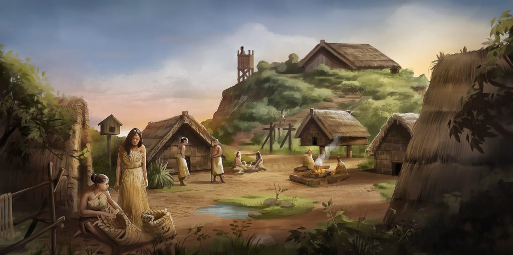
When Māori first arrived in the Hutt Valley it was a place of dense forest of tall timber but also a place abundant with the all important food sources, such as large birds on both the forest floor and in the lofty canopy.
HUTT LANDSCAPE STUDY 2012 Landscape Character Description[3]http://www.gw.govt.nz/assets/council-publications/Hutt%20Landscape%20Study%202012.pdf
The earliest settlements by Māori in this part of the Hutt Valley were of the hapu descended from Whatonga and his two sons, the half brothers Tautoki (the father of Rangitane) and Tara, after whom Wellington Harbour was named (Te Whanganui a Tara).
HUTT LANDSCAPE STUDY 2012 Landscape Character Description[4]http://www.gw.govt.nz/assets/council-publications/Hutt%20Landscape%20Study%202012.pdf
For centuries Māori occupied kāinga (settlements) in the sheltered bays, and more substantial pā on the headlands. As well as The Hutt Landscape Study, I also read on Teara that, “Pā sites include … Oruamatoro (Days Bay) [5]https://teara.govt.nz/en/wellington-places/page-11”.
I also found a record calling it Otuamatoro[6]https://forms.justice.govt.nz/search/Documents/WT/wt_DOC_93656705/Wai%20145%2C%20I009.pdf. More on this later.
Unfortunately, I can’t find any more information where exactly the pā site was located. If I were to guess, I would imagine that it was on the promontory at the top of what’s now Ferry Road, as it’s protected around most of its perimeter by a steep drop off down to the foreshore.
Māori predominantly lived on the coast where the food resource was rich and varied. From the coast hunting parties ventured far inland to draw on those stocks and then returned to the coast.
HUTT LANDSCAPE STUDY 2012 Landscape Character Description[7]http://www.gw.govt.nz/assets/council-publications/Hutt%20Landscape%20Study%202012.pdf
Colonial-ization
Exploration and land acquisition
The New Zealand Company (originally established for a short period in 1826 as the New Zealand Land Company) was a joint stock company formed in 1839 with the purpose of establishing settlements in New Zealand that would put into practice Edward Gibbon Wakefield’s theories of systematic colonisation. Despite being unable to secure the support of the British Government for the project, a preliminary expedition was still despatched by the Company in April 1839. This expedition, under the command of Colonel William Wakefield, was to select a site for the first and principal settlement of the Company, buy land from the Maori, and prepare for the arrival of immigrants. Port Nicholson was chosen as the site for the settlement, which was named Wellington, and settlers began arriving early in 1840.
New Zealand Company Records [8]http://www.nzpictures.co.nz/pandoraresearchANZ-NZC.pdf
Interestingly, in 2003 The Waitangi Tribunal had this to say on the matter:
The Tribunal found that the 1839 deed by which the New Zealand Company purported to have purchased the Port Nicholson block was invalid, conferring no rights on the company or its settlers. However, from 1840, company settlers began arriving at Port Nicholson, and quickly came into conflict with local Māori, who discovered that land which they occupied and cultivated had been sold to settlers.
Te Whanganui a Tara me ona Takiwa: Report on the Wellington District
The first Days Bay Pākehā
According to Colonel William Wakefield, Port Nicholson only had one “white man” living in it in September 1839.
A tree called by the English here the honey-suckle, furnishes excellent wood for boat-building. The only white man living in Port Nicholson showed me a boat of eight tons, which he had constructed of this wood, the planks of which he had bent himself in the sun. He had sawed the whole of it with a hand-saw and made the nails for it out of old hoops.
Colonel William Wakefield’s Journal, September 21st, 1839
Hautrey/Hawtrey Bay
Wakefield and his crew surveyed the harbour and surrounding area. I found an map from 1849 of Port Nicholson, which is the old name for Wellington Harbour, and located Days Bay. It was originally called Hautrey Bay (with a “u”).
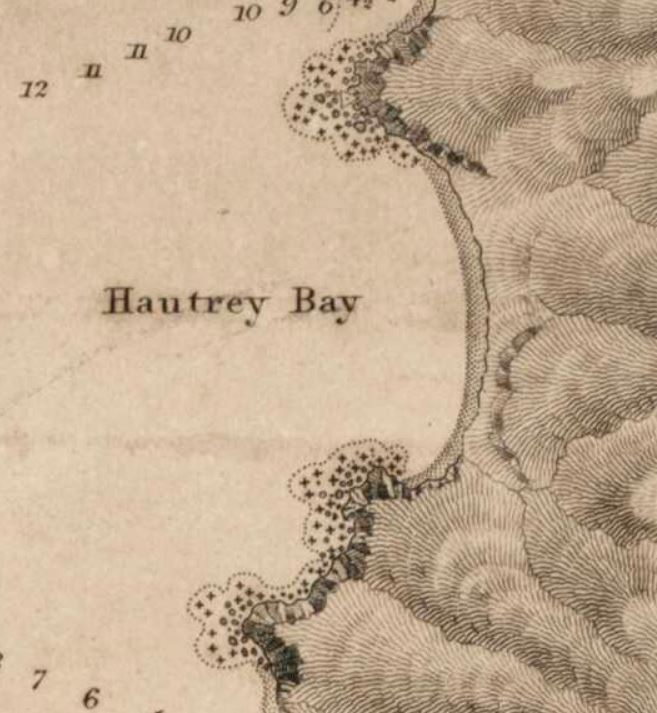
https://ndhadeliver.natlib.govt.nz/delivery/DeliveryManagerServlet?dps_pid=IE212156
Divvying up the land
I found one of the original maps from 1839 that shows how the whole of the Port Nicholson region was sectioned for the settlers. Days Bay was Section #33 and #37. It’s all so… British. Neatly and tidily screw over the local Māori, and extend the empire on which the sun never sets.
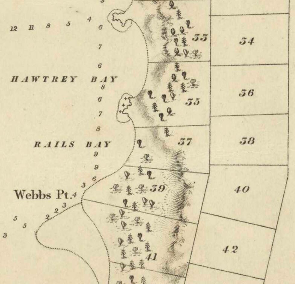
https://ndhadeliver.natlib.govt.nz/delivery/DeliveryManagerServlet?dps_pid=IE1271793
The colonists arrive
On 22 January 1840, the first of the New Zealand Company’s fleet of six immigrant ships, the Aurora, arrived in Pito-one (Petone), marking the founding of the settlement that would become known as Wellington.
There is a fantastic database from Hutt City Council that holds full records of all arriving ships, including log entries and what I can only describe as “ships gossip”, that runs from 1839 to 1897:
http://www.huttcity.govt.nz/Leisure–Culture/Museums-and-galleries/Our-museums/petone-settlers-data/
Mister Day
Days Bay (now without the apostrophe – originally it would have been Day’s Bay) is named for George Day, who arrived in New Zealand in October 1841. That was nearly two years later, so he likely wasn’t the first resident of Days Bay. I decided to see if I could figure out who that was.
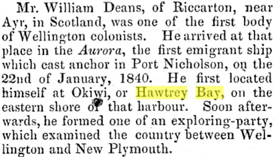
The Brothers Deans
I found a newspaper story from 1851 – an obituary of William Deans, one of the Aurora’s settlers. With his brother, John, he originally settled in Petone, but by March 1841, “had shifted from Petone to Ōkiwi, on the eastern shore of the harbour” [9]https://teara.govt.nz/en/biographies/1d7/deans-john. Interestingly he was “disappointed” [10]https://en.wikipedia.org/wiki/William_Deans with what he found at Wellington, and started looking for other land.
I did find a record of his original section allocation, which was Section 690, but I don’t know where that is yet.
781 13 Aug 1840 W. Deans 690
So, I guess Ōkiwi is Hautrey Bay is Hawtrey Bay is Days Bay? That means Days Bay had its first colonial resident from the first colonist ship. Or did it? This is not so simple yet…
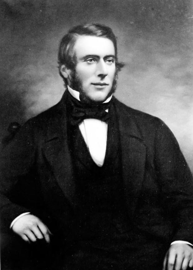
Anyway, this is William Deans’ brother, John; I couldn’t find a picture of William.
Māori connections
In reading the colonial history, there are names coming up for various Māori places, but these are pretty mixed up.
For example, the Deans brothers were known to live at Ōkiwi or Hawtrey Bay, which we know became Days Bay. However, I then found the advert for when they sold their property and moved on [11]https://paperspast.natlib.govt.nz/imageserver/newspapers/P29pZD1OWkNQTkExODQzMDExNy4xLjEmZ2V0cGRmPXRydWU=.
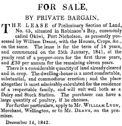
This says they were living at Robinson’s Bay or Okiwi (I guess newspapers maybe didn’t use macrons back then, so Okiwi rather than Ōkiwi), and were leasing section 45, which is indeed not Days Bay. Helpfully, in a document of Waitangi Tribunal Research, I found some place names based on an interview with a Mrs Te Puni in 1912, which sheds a bit of light on this.
| Māori Name | English Name |
| Orua-motoro | Days Bay |
| Okiwi-iti | Browns Bay |
| Okiwi-nui | Robinson’s Bay |
| Matua-iwi | Pa at Robinsons Bay |
There’s also yet another mention of a pā at Otuamotoro. Note the different spelling. Could people be maintaining the idea a pā in Days Bay because they mixed up Otuamotoro and Oruamotoro, or is this just a typo and it’s the same place name?
I really want to find this pā site!
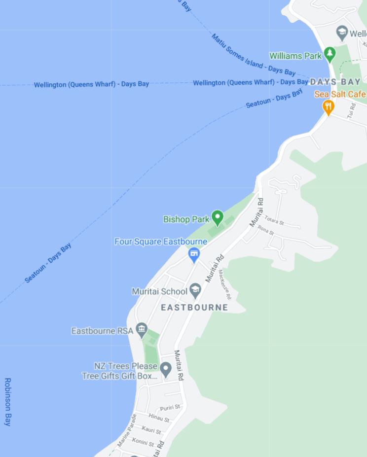
Also, this means that the Deans lived in Robinson’s Bay, which is actually the bay down the coast at Muritai (bottom left on the map below).
Looking at the original New Zealand Company section allocations for the area, that perhaps means the Deans brothers had Section 41 or Section 45, not 33 or 37, which would have been in Hawtrey/Days Bay.
So, who was the original colonist resident of Days Bay?
Well, it I’ll need to keep digging.
My Place
https://ndhadeliver.natlib.govt.nz/delivery/DeliveryManagerServlet?dps_pid=IE1271793
It’s interesting to see how things had change about 70 years later, when Sections 33 and 37 above had become what’s almost modern Days Bay:
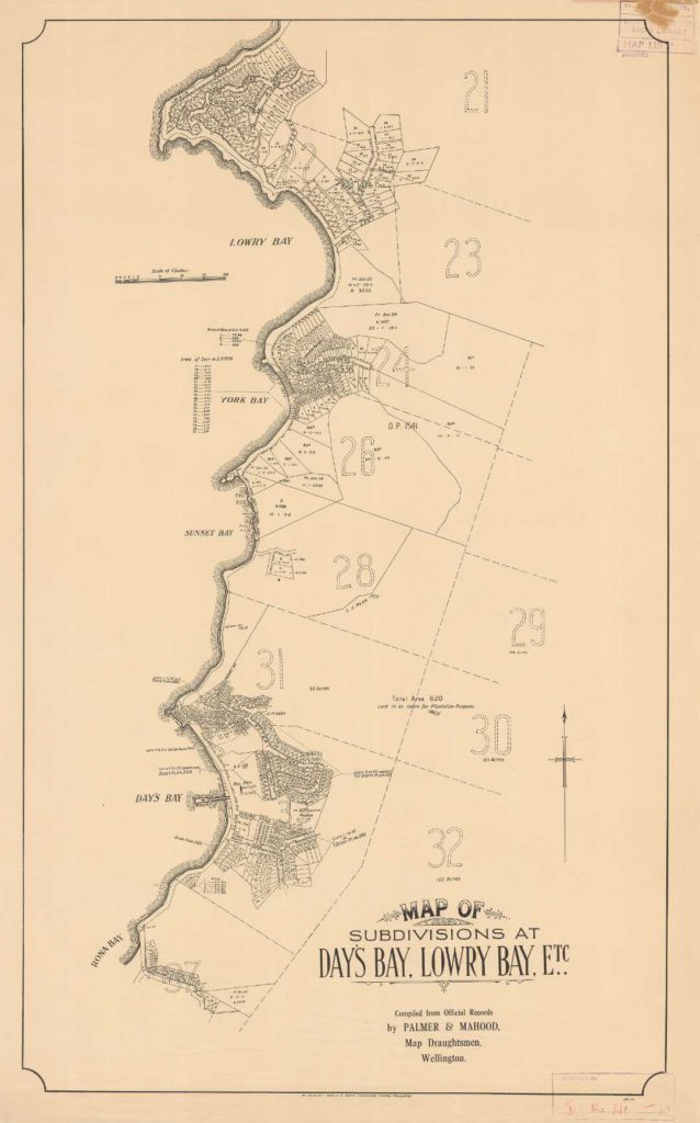
https://ndhadeliver.natlib.govt.nz/delivery/DeliveryManagerServlet?dps_pid=IE18283340
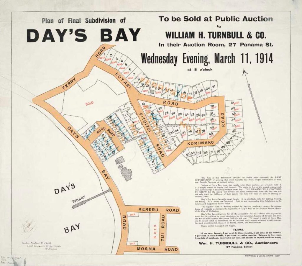
I even found the original sale notice for my own section, which was part of the final subdivision of Days Bay in 1914.
Since then, there have been many more minor subdivisions and building efforts, and I doubt that pattern is going to change any time soon.
Initial thoughts on “Express”
So, I was wondering how I take what I’ve learned so far and produce an artwork that connects things together.
I get a sense that migration into New Zealand in general has been at the expense of went before. The arrival of the Māori had severe adverse consequences on the nature of New Zealand’s landscape and ecosystems, and in particular on biodiversity. Likewise, the arrival of Pākehā and widespread colonization from Europe had similarly detrimental affects; perhaps even worse. These are difficult topics to raise, but we should not be in denial. They’re done with now, we think differently and know more, so let’s look forwards; not backwards.
What might have been
It might be interesting to consider what might have happened if the various human migrants to Days Bay had adapted to what went before, rather than overlaid their own worldviews. This is not to say, “people should have done X or Y”. That’s so pointless – we need to accept reality as it is. Instead, by thinking about what might have been, we can perhaps hope to influence future thought, so that decisions are framed in a different context.
A “what if” artwork
One idea I had is to create an artwork, perhaps a painting or collage, that will show how Days Bay may have looked if arriving peoples had adapted to what went before. We might see the arriving Māori build their village without clearing land; instead, their village could have been sited on the beachfront and in the trees. The arriving Pākehā could have built their own houses and other buildings alongside the existing Māori buildings; perhaps with both the newcomers and the existing residents adapting their buildings to take best advantage of the learnings from both people. Later, as modernization occurred and the wharf and roads were built, we might see the landscape gently adapted to take them in. Not a layering of one culture over the previous one, but an interweaving and intermingling.
How to do this?
Illustrating Days Bay as a whole is difficult – it’s best seen from the water. Fortunately, the wharf sticks out into the bay, so showing the view of Days Bay from the end of the wharf is an option.
Perhaps, as a start, a series of photos, sketches, and illustrations. Show Days Bay, try to show what it would have looked like before humans arrived, then show how the Māori village could have looked, then how the 18th Century colonists might have adapted to the bay, and so on. As a final artwork, create a combined illustration that shows how Days Bay could look.
References
| ↑1, ↑2, ↑3, ↑4, ↑7 | http://www.gw.govt.nz/assets/council-publications/Hutt%20Landscape%20Study%202012.pdf |
|---|---|
| ↑5 | https://teara.govt.nz/en/wellington-places/page-11 |
| ↑6 | https://forms.justice.govt.nz/search/Documents/WT/wt_DOC_93656705/Wai%20145%2C%20I009.pdf |
| ↑8 | http://www.nzpictures.co.nz/pandoraresearchANZ-NZC.pdf |
| ↑9 | https://teara.govt.nz/en/biographies/1d7/deans-john |
| ↑10 | https://en.wikipedia.org/wiki/William_Deans |
| ↑11 | https://paperspast.natlib.govt.nz/imageserver/newspapers/P29pZD1OWkNQTkExODQzMDExNy4xLjEmZ2V0cGRmPXRydWU= |
| ↑12 | https://vflanagan.artstation.com/ |
237.130 Submission #2 Express
Initial idea
I want to create some kind of artwork, perhaps a painting or collage. We discussed our ideas as a group in class, and it appears that a collage is a pretty “standard” idea, but to be blunt I’m really not a fan of collages. That doesn’t make it a bad idea per se. So, where next?
Reimagining colonization?
How might Oruamatoro have looked if arriving peoples had integrated into what went before? We might see the arriving Māori build their village without clearing land; instead, their village could have been sited on the beachfront and in the trees. The arriving Pākehā could have built their own houses and other buildings alongside the existing Māori buildings; perhaps with both the newcomers and the existing residents adapting their buildings to take best advantage of the learnings from both people. Later, as modernization occurred and the wharf and roads were built, we might see the landscape gently adapted to take them in. Not a layering of one culture over the previous one, but an interweaving and intermingling.
That’s the physical dimension of this, but it’s important not to overlook the other aspects of the course. We explored how people felt about colonization. How the legal frameworks developed. How the concepts of sovereignty and ownership are important factors. How The Treaty of Waitangi is not quite the same thing as Te Tiriti o Waitangi, and so on.
Refining the idea
So, let’s look at something that’s personal to me, and how that might have been different, if the path New Zealand had followed was different.
The three maps below are personal to me, because they include the section of land that I own and live on. In the first map, Days Bay was shown as a bare and empty shore, in spite (literally spite?) of the two Māori villages and pā site on the Northern headland, which the Royal Navy didn’t bother showing:
https://ndhadeliver.natlib.govt.nz/delivery/DeliveryManagerServlet?dps_pid=IE212156
The second map shows that Hawtrey Bay (now Days Bay) had become Section 33, assigned to an incoming colonist:
https://ndhadeliver.natlib.govt.nz/delivery/DeliveryManagerServlet?dps_pid=IE1271793
And finally, in the third map – actually an advertisement – the original section has been subdivided into the classic “quarter acre” sections dear to Kiwi hearts:
https://natlib.govt.nz/records/20911227
There’s a lot wrapped up in this final advertisement that’s worth unpicking.
Traditional Māori society did not have a concept of absolute ownership of land. Whānau (extended families) and hapū (sub-tribes) could have different rights to the same piece of land. One group may have the right to catch birds in a particular clump of trees, another to fish in the water nearby, and yet another to grow crops on the surrounding land. Exclusive boundaries were rare, and rights were constantly being renegotiated.
- This is, obviously, a map. It draws boundaries that are only really relevant to a Western mental model.
- The map shows land boundaries that originate in the original colonial plans for Port Nicholson.
- Areas of land are for sale.
- How would this have been pitched if ownership was not the default?
- What type of property arrangement would have been made, if the legal framework we’re operating under better reflected mātauranga Māori?
- Would the mechanism still have been a sale by auction?
- Could some different kind of contractual approach been used?
- Would there still have been a map? If so, what might that map have looked like? What else would have been on the map? Shared space?
- Would there have been Māori influence in the advertising?
- Would Te Reo have been used in the text?
So, my initial idea is to recreate some of the early advertising, to show what it might have looked like if the audience were people who would be integrating into Days Bay, rather than simply overlaying their culture on top of the area.
Some questions to think about…
Until 1839 there were only about 2,000 immigrants in New Zealand, and perhaps 70,000 Māori; by 1852 there were about 28,000 immigrants.
So, what would the advert have been proposing? Perhaps the local Iwi would be offering to hold a hui with interested parties, to discuss how mutually beneficial arrangements could be made, so that people moving to New Zealand would have a place to call home?
Perhaps, in the spirit of continuity and to show flexibility towards Western customs, the Iwi were willing to negotiate a term for the agreement, to allow whanau with young families to settle until the parents passed away, or until a mutually agreeable date, whichever was shorter.
Included in the agreement for an area of land for a house to be built could be rights to use the common facilities in Days Bay, for example to hunt in the hills behind the bay, or to fish in certain areas.
The local Iwi might have been looking for people who had valuable skills to bring to the community, or who were willing to invest in the community in various ways. There may be no fixed ideas about this – this could have been the start of a dialogue, and the hui could be for the people of the Iwi and the new immigrants to get to know each other and start discussing how best to live together.
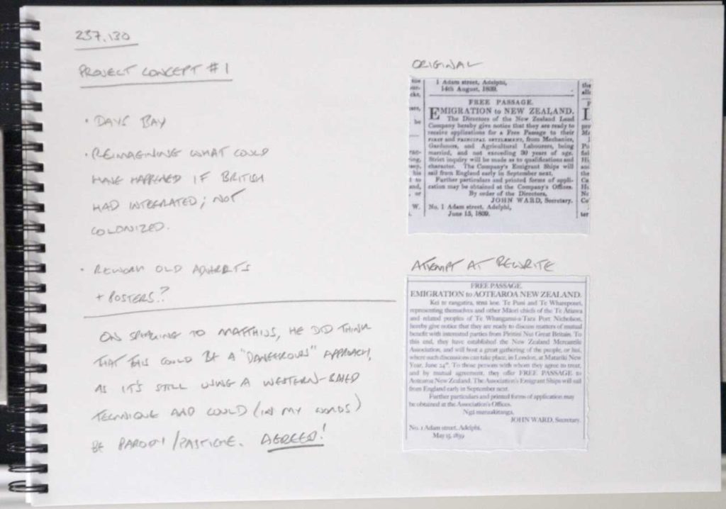
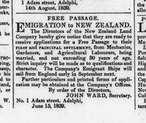
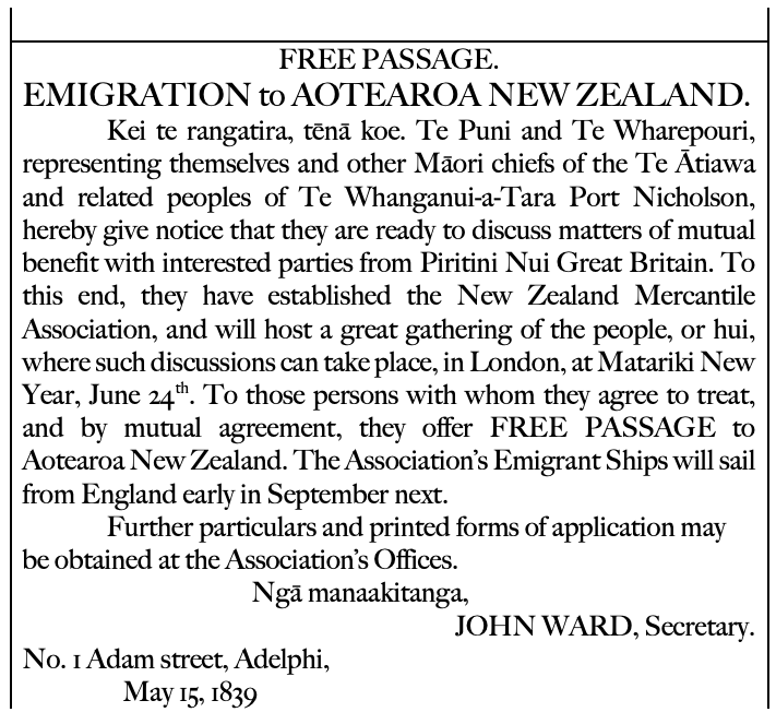
Re-imagined information – Concept #1
My first experiments
Maybe look at these next?
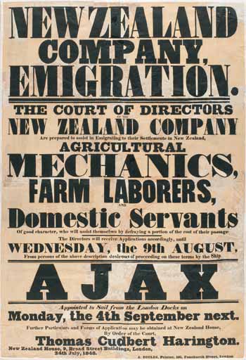
Jock Phillips, ‘History of immigration – British immigration and the New Zealand Company’, Te Ara – the Encyclopedia of New Zealand, http://www.TeAra.govt.nz/en/ephemera/2096/new-zealand-company-poster (accessed 10 May 2021) 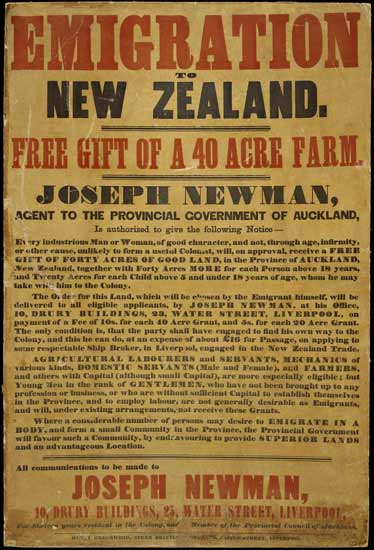
Fiona Barker, ‘New Zealand identity – The land’, Te Ara – the Encyclopedia of New Zealand, http://www.TeAra.govt.nz/en/ephemera/34600/emigration-poster (accessed 10 May 2021)
Stop! Pause for breath…
Having spoken to Matthijs, he pointed out something really obvious here: that I’m still approaching this from a Western mode of thinking. He suggested that this is a potentially dangerous road to go down.
So, I took this opportunity to speak to a Māori colleague about this (albeit briefly), and yes, I’m on a concerning track.
This feels like you’re trying to say, “if only Pākehā had understood Māori tikanga, everything could have worked out differently and everyone would have lived happily ever after”. That sounds very naïve and Pollyanna, and you’re still telling the story from a Pākehā point of view.
(Quote as remembered by me – anonymous by request)
At that point, I pretty much gave up on that idea, and moved onto to think a lot more about what I wanted to achieve through this piece.
Also, I’d view it as a kind of failure if I didn’t really push myself outside my comfort zone with this.
I can default to a kind of, “yes, Māori lived here, they got displaced, let’s tell the story of that and try and relate to it”. But, is that really what I want to say about the place I live, or I am being constrained by the expectation boundaries of this course?
What do I really want to do?
What am I trying to get across? I want to show that:
- I understand (probably more than quite a lot of local Kiwis) something of the history of Oruamatoro/Days Bay;
- I acknowledge that my understanding of pre-colonial history is pretty weak;
- I feel like I’m missing out on connecting to a really important part of New Zealand heritage;
- my section is an interestingly off triangle shape;
- I have a strong connection to the three countries in which I’ve lived;
- incompleteness in my reconciliation of my place in New Zealand, and that I am essentially still living as a European; and
- finally, there’s a sense of imbalance in my understanding.
I do want to show that I’ve got a new understanding of Days Bay, and that it has affected my understanding of where I’m living. But, there’s more to it than that. I also want to reflect my long time and history living in the UK and the baggage that brings, and I want to do the same for my time in Japan.
I have reconciled my experiences with those two countries, and I have yet to reconcile my life in New Zealand. I want to show that. That, I guess, is that imbalance I’m feeling.
More refinement – Concept #2
Next, thought though how I might use the triangle idea as a kind of scaffolding on which to show my knowledge, and lack of knowledge, and the unbalanced/unfinished feeling that I have.
I came up with another concept, which was to build a canvas on a triangular stretcher, but leaving the canvas edges raw. Then, collage onto it some of the information that I’ve gathered during the “explore” phase of the project and some more things about my memories of the UK and Japan for contrast:
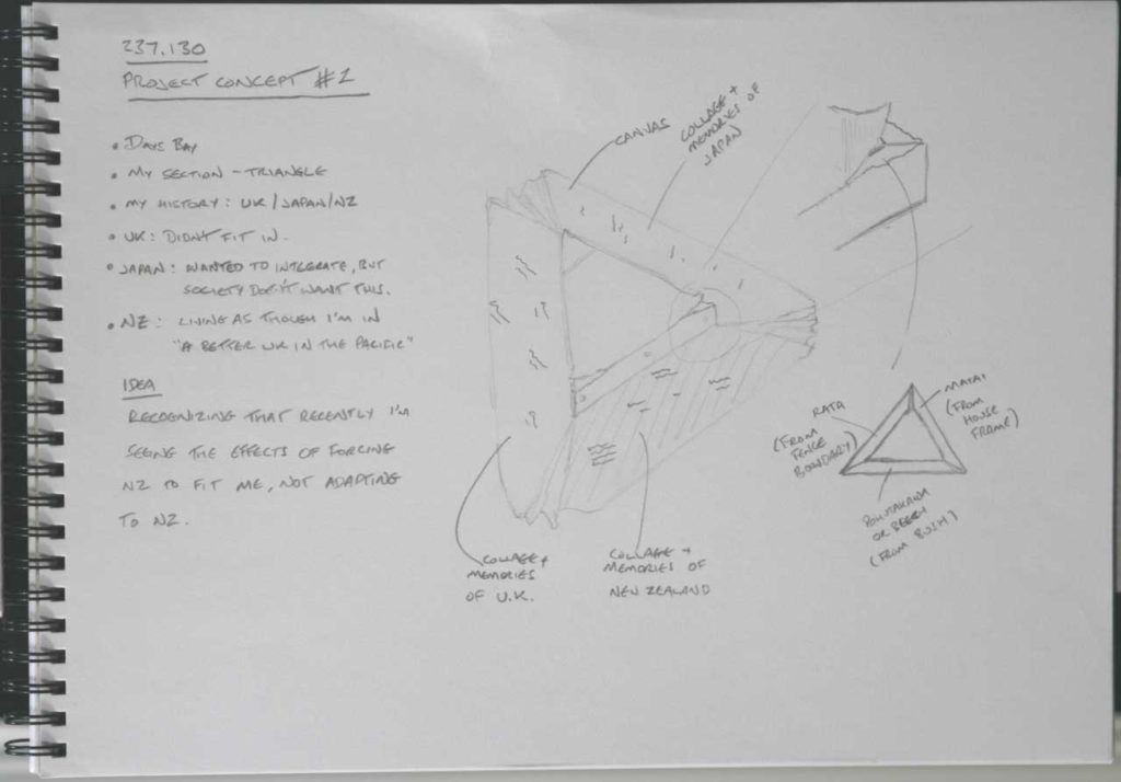
This felt kind of interesting, but I don’t need the UK/Japan things on it to make my point. It felt like this should be about New Zealand, and my pre- and post-colonial understanding.
I also had the idea of laminating native wood and imported wood together to make a strong framework, but this felt a bit forced somehow. I didn’t let it go though – love my woodworking too much!
I didn’t feel that this concept showed enough of that unbalanced/unfinished feeling, so I kept thinking about it rather than jump straight into making it.
Concept #3
The next concept was to use a regular canvas as a kind of foundation, but to have another partially formed canvas emerging from it.
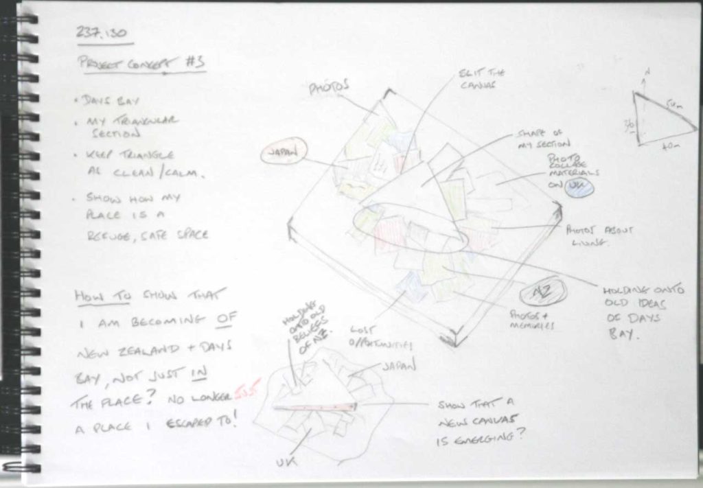
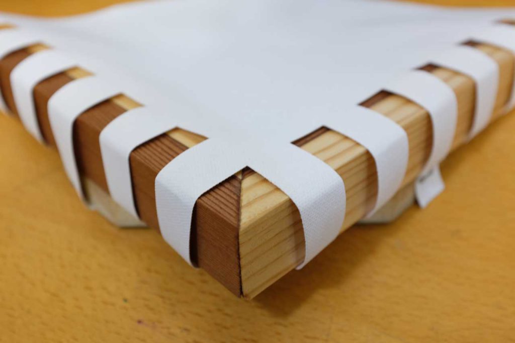
A kind of unformed, unfinished canvas emerging from a mass of information. I could re-use an old canvas for the main one, and I could have used a similar premade canvas for the emerging one, but I would have had to cut it up anyway, so I thought I may as well build a stretcher and put raw canvas on it myself. I had the idea of using a native and non-native timber for the framing, to show a kind of laminated, stretch-in-unity idea, but that started to feel a bit too forced.
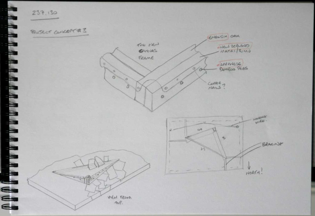
Before I abandoned the idea, I did actually go ahead and build the wooden frame using native matai timber (from an offcut of old weatherboard) and some plain pine, with a raw canvas covering. On completion though it just feel too busy and fussy for what I was trying to achieve, so it went unused. It will no doubt get reused for another project.
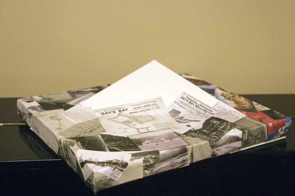
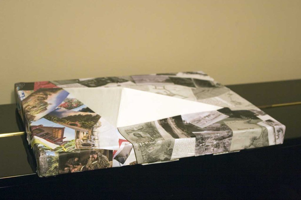
So, having given up on the wooden frame, I realised that I could get a better, and lighter weight, effect if I built the emerging canvas from corflute. Rather than stick to my original idea of the frame being a canvas, I made the emerging triangle bigger and little more dramatic. It still adhered to my original concept though, as the foundation canvas was unchanged and still had the hole in it the exact same shape as my section.
The completed piece
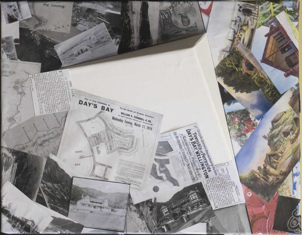
When I started to assemble the piece, I realised that a lot of the photos and articles that I’d collected of colonial history dated from the 19th and early 20th century, so were in mainly black and white. The images of Māori life were in the main more recent photos and illustrations. This gave me an idea: I could use only black and white items to represent my knowledge of colonial history, and use colour to show the gap in my understanding of mātauranga Māori.
So, I rearranged my items and then fit them to the shape of the underlying composite canvas, giving the result below.
237.130 Submission #3 Reflect
Reflect? I don’t think I’ve done much except reflect on this course over the past 13 weeks, and I would imagine that by now I’ve thoroughly bored my family, friends, and colleagues.
The course has genuinely changed the way I think, and I’d like to comment on two items in particular (there were many others).
On Design and Accessibility
Here is a comment taken from my notes:
Every design decision for a built environment is necessarily an active choice. It’s a choice between providing access to people who are living with disability, or, choosing to disadvantage them by denying or restricting their access.
Notes on Session 2: Curious Instances
Looking at the built spaces around me, for example my own home and workplace, I find myself constantly evaluating the design choices that were made.
My home has stairs, and no access to the upper storey – most two storey homes in New Zealand are like this. The only ways into my house have steps, and none of the fixtures and fittings enable use by disabled people.
At work, we have lifts, but in the event of a fire we have no other means of egress except stairs in tight stairwells. The whole office is (apparently) “smart”, which in real terms means that even the light switches are tiny recessed push buttons. None of our ultra-modern printers are able to be used by people in wheelchairs, because their touch panels are too high and angled upwards.
And so on.
These are just basic examples, but illustrative. Design is always a choice – we should be aware of the enabling or disabling effects of those choices.
Finally on this topic, one thing I regret about my project was that I did not explore how my piece could have been made more meaningful and accessible to people living with disability. This is something I can see having an influence on me as I develop as an artist.
On Māori
The second item I’d like to note is how the course challenged me to reflect on my own relationship with Māori.
Yes, I’m Pākehā, but my history in New Zealand now feels connected, and I want to know more about the full history of our country and Oruamatoro / Days Bay, and learn what it means to have an equitable and interdependent relationship with other New Zealanders.
Extract from my presentation to the class
Sessions 7 and 8 were a turning point, and tough. The conversations felt far too polarized, and reading back through my notes and reflecting on them, they still do. Colonization had negative effects on Māori. New Zealand’s biodiversity suffered negative effects from both Māori and European colonization. These are two facts, and it’s not “whataboutism” to discuss them together. I doubt I will ever move beyond my extremely strong feeling that this should be a more nuanced conversation.
If I am to engage adequately with these difficult topics, then I must learn more about Māori. It’s naïve and crass to debate things otherwise, and it’s also far too easy to be dismissed if you can’t “show your working”. As a start, and supported by my employer, I am learning Te Reo Māori. I know from personal experience of life in Japan that you can’t hope to fully understand a culture if you can’t speak the language. I will also be taking advantage of the many opportunities at work to understand and work alongside Māori – something that I know my organization values and supports.
So, why did I not learn Te Reo Māori 10 years ago? That’s a the reflection in and of itself: I don’t think I was willing or able to step outside my European bubble and really connect to the full history and culture of New Zealand.
In summary, this was a fascinating, frustrating, humbling course. Thanks for the opportunity.